Reality of the Situation
Throughout history, societies have recognized the inherent value of using drawings and paintings to document and communicate moments in time. Technology has continued to make great strides in information communication, resulting in significant increases in the speed and accuracy with which we are able to visually depict the world around us.
With the invention and proliferation of technologies such as camera obscura, film cameras, digital cameras and eventually 360-degree panoramic images, people have become ever more enamored by the idea of artificially replicating and sharing their individual moments, showing others not only what they witnessed from a stationary vantage point, but how they experienced the moment from every angle conceivable.
Their fascination is justified, as the recent advancements in virtual reality have allowed for the creation of fully immersive environments where users can now move through spaces in an increasingly lifelike fashion. One technology that is making virtual reality more relevant and accessible, especially in the lives of architects, is known as point cloud mapping.
The XYZ’s of 3D Coordinate Systems
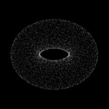
Point cloud maps are a series of individual dots that work together to form a digital model of an existing space. The science behind how the model is created is comparable to the way certain animals use echo-location to navigate through environments. A 3D scanning survey tool is placed at a fixed point and sends laser pings out into the world. Upon striking a solid surface, the lasers rebound back to the scanner, and the time it takes for them to return is calculated. The scanner then compiles the data in the X, Y and Z planes and forms a picture of the environment capable of being rotated and viewed from any direction.
The automobile industry often makes headlines for a similar technology being used to foster the viability of self-driving cars. This is but one example where point mapping could dramatically alter how an entire industry operates. There are endless opportunities in which the technology can be applied, including one that is extremely applicable to my work at MG2, architectural investigation. Any architect with access to this technology can now compose a comprehensive model of a space with a high-degree of precision. This is invaluable information when designing and working with an existing building.
Connecting the Dots Between an Emerging Technology and our Work with Costco
In recent years, MG2 has supported long-time client Costco Wholesale’s increased emphasis on a rapidly expanding division of its business model, the Costco business center. Although open to all Costco members, in comparison to the traditional Costco warehouse, these business centers are designed with a smaller footprint and merchandised with products to serve the needs of local businesses.
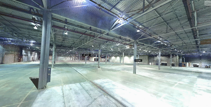
A major difference also exists in that business center projects are not built from the ground-up. All 13 Costco business centers opened thus far have been rehabilitation projects of existing warehouse spaces. One such project, currently in progress, involves the revitalization of a 70-year-old former Levitz Furniture warehouse located in San Francisco.
The original drawings of the building were an excellent starting point for developing construction documents, but the fact they were drawn in 1956 and then scanned to retain digital copies made it incredibly difficult to decipher crucial details. Also adding to the challenge, many of the details shown on the original drawings were no longer relevant as the building has changed over time, and many of the new elements added to the building throughout the decades failed to ever be documented. Our partner, Span Construction, brought forth the idea and the technology to create a point cloud map of the existing warehouse.
Span’s adoption of the technology has been instrumental in providing MG2 the ability to develop a set of accurate working drawings and save our client money. In a standard Costco business center renovation project, MG2 architects must visit the site in-person, measuring, documenting and gathering as much data as possible. Inevitably, additional measurements will need to be captured, requiring added days to travel and gather the missing data by physically visiting the site again, which is costly.
By including the building of a point cloud map as part of the schedule during our initial site visit, not only do we get the experience of assessing the site with our own eyes, we also gain a complete and accurate digital reference we can access moving forward. Instead of taking days and spending thousands of dollars to answer a question, MG2 can now find the required information in mere minutes.
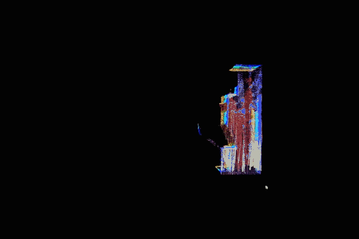
For instance, as part of the San Francisco warehouse project, we had questions about how the roof structure was laid out. Because we had the point cloud map, we were able to spin the building around on our computer screens and take a look at the underside of the roof, enabling us to fully understand the placement of roof drains, sprinkler lines, lights, trusses, purlins, and even view the individual ribs of the metal roof deck. This information allowed us to quickly locate and dimension all building elements within the scan.


Applications, Limitations and Opportunities for 3D Scanning
One of the benefits, and also one of the downfalls, of the point cloud map is its integration capabilities with other platforms. Architects are able to easily import point cloud maps into CAD and BIM programs, but when introducing the point cloud into these third-party software systems, they simply register as a cluster of points. Thus we are required to go back through and create any vectors or planes that are associated with the point cloud. Although this process can be tedious, using this technology is still much more efficient than having to rely on “as-built” drawings.
For our specific purposes, MG2 has been creating drawings separately from the point cloud and then using the data points to go back and verify locations of columns, walls, doors, etc. One can speculate over the next few years however, point cloud maps will be able to directly translate into solid surface models, making the process a lot less labor intensive.
Another opportunity for improvement involves efficiency. Depending on the size and complexity of the building, it presently takes between one to two days to fully scan the entire structure. In the case of a large building, such as a Costco business center warehouse, the 3D scanning survey tool must be placed in more than 80 different locations throughout the space in order to complete the millions of individual scans necessary to develop a full picture of the building.
This finished scan can often exceed 30 GB of data. Due to the massive file sizes involved, once uploaded to MG2’s server, our ability to access these models remotely via laptops is nearly impossible due to the memory limitations of most portable devices and the immense time it would take to transmit the data wirelessly.

The Next Evolution of Point Cloud Mapping
In the not too distant future, I envision the aforementioned issues being resolved and point cloud mapping technology becoming increasingly effective, affordable and accessible within the marketplace. Once that occurs, it will have major implications on the field of architecture in terms of boosting the ease and accuracy in which architects are able to verify real life conditions in real time.
In juxtaposition to the practice of architecture, where even the most visionary designs must adhere to the rigid laws of physics, the methods being used to document moments in today’s digital age have become almost infinitely flexible, serving as capsules for incalculable volumes of information, operating in multiple dimensions and integrating into software systems with potentials yet to be fully realized. We are at a point in history where the very definition of what it means to “capture a moment” is being revolutionized. I’m proud to be a part of team embracing an emerging technology that enables architects to give clients the entire picture.